
Action Strategy
An Action Strategy is one of the final components of the WMP. It is the result of water quality analysis, geographic analysis, public input, parcel analysis, etc. The UMRWP’s goal is to improve the water quality of the Mississinewa River. To do this, we will continue our current efforts to educate the public about the river and Best Management Practices (BMPs), raise cost-share funds to support the implementation of BMPs, provide technical assistance, and promote the formation of partnerships within our communities.
Components of our Strategy:
Target Landowners
The UMRWP will continue to develop a relationship with our target audiences described in previous newsletters. Purdue Extension estimates that 50% of landowners in the region are non-producer/renters while 50% are producer/landowners. The UMRWP will seek to differentiate between these two audiences and tailor its education and outreach efforts to these specific subgroups. The over-arching goal will be to build social networks within each subgroup and develop educational resources based on the needs and interests of each unique subgroup.
Partnerships
The UMRWP will build relationships with regional Health Departments and Sanitary Districts, sharing water quality results,and partnering where possible to reduce E. coli from septic and CSO sources.
Collaborating with Ball State University and Taylor University
Universities in the region will work with the UMRWP in developing innovative education and cost-share promotion media including videos, interactive web resources, mobile GeoForm data collection applications, and ArcGIS Online maps and ArcGIS “story maps”. Finally, the UMRWP will work with local conservation organizations to increase awareness of recreational opportunities along the Mississinewa River and at Mississinewa Lake Reservoir by: (a )Guiding local groups in the application and removal of canoeing impairments such as logjams and dams, (b) Educating about health and safety issues relating to full body contact. (c) Assisting local conservation groups in creating additional canoe access sites, and (d) Hosting a clean-up/canoe run or clean up.
“Focus on unseen” Water Quality Impairments
As mentioned in previous newsletters, “unseen” impairments such as pathogens, nutrients, and sediment were concerns rarely mentioned on comment cards and/or at public meetings,yet these concerns are the primary causes of watershed water quality problems in the region. Educating landowners about these parameters and how they relate to their (a) health (recreation and drinking water), (b) fish and widlife, and (c) socioeconomic concerns, are a goal of the project.In response, UMRWP will develop an education initiative that: 1.Explains the health risks associated with drinking and/or having full body contact with polluted waters (pathogens & nutrients/algae). 2. Emphasize the connection between rainfall, land-use,and aquifers (wells/drinking water), and will, 3. Use Hoosier RiverWatch (CHEMetrics and ColiScan) methods/testing kits as a means of educating the public in how to “see” the unseen water quality impairments affecting the regions water quality. The UMRWP will demonstrate these methods (a) through interactive exhibits at trade shows/festivals, and (b) by documenting sampling events and chemical testing procedures in a video format to use on website/social media.
Water Monitoring
The UMRWP will continue our monitoring program in subsequent phases in collaboration with local universities, stakeholders, and citizens. Delaware County GIS will work with the UMRWP in developing methods for grass-root data collection and the execution of supplemental water quality data collection/analysis programs. This collaborative partnership will equip students and community members in the watershed to use a variation of Hoosier River Watch level water quality methods/assessment. The development of a capable volunteer base will allow for a cost-effective monitoring of installed BMPs at either the site or watershed subwatershed scale.
Develop Policy Orientation
The UMRWP will seek to better understand local policy and ordinances related to water quality, drainage, land management, and conservation.The UMRWP will work with landowners and representatives to explore opportunities for local policy proposals and/or changes.
Cost-share Programs:
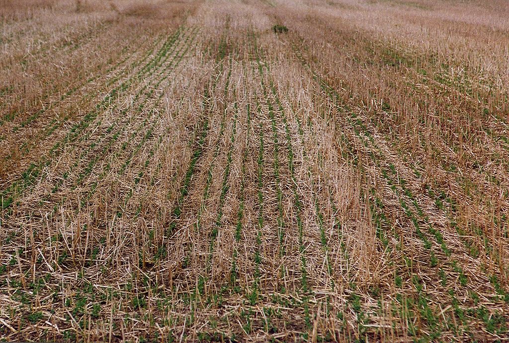
FIG 1 | Structural BMPs include practices like no-till planting.
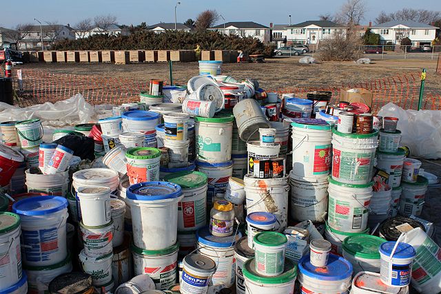
FIG 2 | Behavioral BMPs are actions, such as the proper disposal of household wastes. Household wastes disposed of in an improper manner can enter groundwater and surface waters.
Webinars:
- Clean Water Indiana
- IDEM 319 Program
- LARE
- Delaware County Cost-share
- Misc. Cost-Share
- NRCS Cost-share
Clean Water Indiana
The Clean Water Indiana Program is a program of the Indiana State Department of Agriculture. The fund is administered by the State Soil Conservation Board (SSCB). The program is funded by the State Cigarette Tax. The program provides cost-share funds for practices and projects that reduce sediment and nutrients. Grants are awarded to Soil and Water Conservation Districts.
The Delaware County Soil and Water Conservation District, in partnership with the Grant, Blackford, and Randolph SWCDs, was awarded a Clean Water Indiana grant for $123,303 for 2017. The grant will help fund a variety of projects, including the stream bank stabilization project on Deer Creek in Grant County, invasive species removal at Wilderness Park in Hartford City, and cost-share practices for producers and landowners.
IDEM 319 Program
The 319 grant program funds a federal pass through grants that are administered by the State of Indiana. The grant takes its name from the piece of legislation that authorizes it, Section 319(h) of the Clean Water Act. This grant provides funding for a variety of projects which aim to reduce nonpoint source water pollution. Funding can be used for a variety of purposes, including assessments, demonstrations, education, outreach, and the implementation of watershed management plans. The grant requires a non-federal in-kind or cash match of 40 percent.
The UMRWP has applied for a 319 grant for the 2017 federal fiscal year and was awarded $210,000, $150,000 which was to be used for cost share funds. This 319-grant has a heavy emphasis on cost-share practices for land owners and producers intended to reduce pollutants identified in previous studies. The 319-implementation grant ran from May 2018 through May 2021. The main objective of the grant is to make recommendations based on scientific data and community concerns for reducing non-point sources of pollution within the Upper Mississinewa River Watershed (UMRW). The 5 goals developed from the 319-grant and the objective are:
1. Develop a watershed management plan (WMP) for the UMRW,
2. Develop, promote, and implement a cost-share program,
3. Develop and implement a quality assurance project plan (QAPP) and water quality monitoring program,
4. Conduct an education and outreach program,
5. Prepare and submit quarterly progress reports and financial project summaries to IDEM.
A total of $150,000 cost-share funds were made available throughout the three-year process. In 2019, 17 projects totaling $48,010.01 (36%) were funded. In 2020, ten projects totaling $20,509.36 (16%) were funded. In 2021, 8 projects totaling $61,1188.30 (48%) were funded. Overall, $129.717.70 of cost share funds were used and implemented within the watershed. A total of 42 projects consisting of 3,270.39 acres of cover crops and 133.27 acres of forage and biomass have been completed. A unique equipment modification was completed and two grassed waterways were constructed.
The Upper Mississinewa Watershed Partnership 319-Project was a success. While no funding has been secured, the SWCD and the UMRWP will continue to search out and apply for funding to ensure the continuation of the project.
The UMRWP applied for additional 319 funding from IDEM in August 2021. This project would increase the amount of cost-share funds by reducing the education and outreach aspect of the project. The applied for funding also opened up cost-share funding opportunities to additional critical areas within the watershed. This project was not awarded and will be applied for again in the future.
LARE
The Lake and River Enhancement Program (LARE) is a grant fund created and administered by the Indiana Department of Natural Resources through the sale of hunting, fishing, and boating licenses. The program’s goal is “to protect and enhance aquatic habitat for fish and wildlife, and to insure the continued viability of Indiana’s publicly accessible lakes and streams for multiple uses, including recreational opportunities.” To do this, the program administers funds to reduce non-point source pollution reaching surface waters.
The UMRWP has received four LARE grants, which have funded logjam removal on the Mississinewa River in Randolph County, engineering feasibility studies on Walnut Creek and the Mississinewa River, both in Grant County, and a stream bank stabilization project on Deer Creek in Grant County. The UMRWP applied for additional LARE grants in 2017.
Delaware County Cost-share
For landowners who have indicated an interest in participation in UMRWP cost-share programs, the Partnership has developed a methodology for beginning the application process. Application forms are available on request and downloadable from the UMRWP website. Cost-share enrollment is ongoing but many NRCS programs have seasonal application deadlines or constraints. Contact your NRCS District Coordinator or SWCD Project Manager for more information on the UMRWP application process or suggestions on how to use UMRWP research and water quality data to make applications more competitive. We look forward to sharing our water quality results with landowners and assisting in the cost-share application process.
Miscellaneous Cost-share
Landowners in Delaware County are eligible to participate in many different cost-share programs. The most commonly awarded programs are CRP, CREP, EQIP, WHIP, and CFWP. While the UMRWP cost-share program is separate from these sources of funding, there are opportunities for partnership and pooling of resources. Before the UMRWP awards grants out of the 319 funding, we often check to see if some of these other programs might be available for higher amounts of funding and for longer time periods.
The UMRWP would be happy to assist you in learning more about your cost-share options – both through the UMRWP or through the below programs.
Entire List of Programs
Indiana Classified Forest and Wildlands program
The Classified Forest and Wildlands Program encourages timber production, watershed protection, and wildlife habitat management on private lands in Indiana. Program landowners receive a property tax reduction in return for following a professionally written management plan. In addition to the tax incentive, landowners receive free technical assistance from DNR foresters and wildlife biologists, priority for cost share to offset the cost of doing management, and the ability to “green” certify their forests. The minimum requirement for program enrollment is 10 acres of forest, wetland, shrubland, and/or grassland. Enrolling your forests or grasslands (has to be at least a 10 acre parcel) will drop your property taxes to $1 per acre. Managed harvesting of timber is still allowed in this program.
Emergency Conservation Program
Get back on your feet after a natural disaster. USDA Farm Service Agency’s (FSA) Emergency Conservation Program (ECP) provides emergency funding and technical assistance for farmers and ranchers to rehabilitate farmland damaged by natural disasters and for carrying out emergency water conservation measures in periods of severe drought.
Emergency Forest Restoration Program
Emergency Forest Restoration Program (EFRP), which will make payments available to nonindustrial private forest (NIPF) land owners who are approved for program participation in order to carry out emergency measures to restore land damaged by a natural disaster.
Farmable Wetlands Program
The Farmable Wetlands Program (FWP) reduces downstream flood damage, improves surface and groundwater quality, and recharges groundwater supplies by restoring wetlands.
Grassland Reserve Program (GRP)
The Grassland Reserve Program (GRP) helps landowners restore and protect grassland, rangeland, pastureland, and shrubland and provides assistance for rehabilitating grasslands.
Source Water Protection Program
Source water is surface and ground water that is consumed by rural residents. The Source Water Protection Program is designed to help prevent source water pollution through voluntary practices installed by producers at local levels.
Conservation Tillage Program
No-till revolutionized the industry of agricultural production during the 1990s. Less than 10 percent of all cropland was managed in a no-till system in 1990. Initially, corn was considered the better adapted crop for no-till. In 1990, the percentage of crops managed in a no-till system were nine and eight percent for corn and soybean, respectively. By 1992, the curves for corn and soybean no-till adoption were diverging. Soybean were better adapted to the no-till environment than the corn hybrids of that time. Management skills for no-till corn were realized to be more demanding than for no-till soybean. The no-till drill facilitated a no-till soybean production boom. This update provides a summary of trends associated with the adoption of no-till crop production, crop residue cover, and soil loss. This data was obtained as a result of spring surveys of Indiana cropland. In an “average sized” Indiana county, a sample size of 450 crop fields produces a 95 percent level of confidence. To learn more about conservation tillage and how you can incorporate it into your operation visit the Conservation Cropping Systems Initiative website.
Resource Conservation and Development (RC&D)
The purpose of the Resource Conservation and Development (RC&D) program is to accelerate the conservation, development and utilization of natural resources, improve the general level of economic activity, and to enhance the environment and standard of living in designated RC&D areas. It improves the capability of State, tribal and local units of government and local nonprofit organizations in rural areas to plan, develop and carry out programs for resource conservation and development. The program also establishes or improves coordination systems in rural areas.
Farm and Ranch Lands Protection Program (FRPP)
The goal of the Farm and Ranch Lands Protection Program (FRPP) is to protect prime or unique farmland, statewide and locally important soils, or historic and archaeological resources on farmland and ranch land from conversion to non-agricultural uses. The program preserves valuable farmland for future generations; protecting agricultural land use and related conservation values of the land. This goal is achieved by working cooperatively with State, Tribal, and local government entities and non-governmental organizations. FRPP provides matching funds to help eligible entities purchase development rights to keep productive farmland and ranch land in agricultural uses. USDA provides up to 50 percent of the easement fair market value. To qualify, farmland must: be part of a pending offer from a State, tribe, or local farmland protection program; be privately owned; be large enough to sustain agricultural production; be accessible to markets for what the land produces; have adequate infrastructure and agricultural support services; and have surrounding parcels of land that can support long-term agricultural production.
Grassland Reserve Program (GRP)
The Grassland Reserve Program (GRP) offers landowners the opportunity to protect, restore, and enhance grassland including rangeland, pastureland, shrubland and certain other lands on their property. USDA’s Natural Resources Conservation Service and Farm Service Agency administer this program. This voluntary program helps protect valuable grasslands from conversion to cropland or other uses and helps ensure that grasslands are available to future generations. Participants voluntarily limit future development and cropping uses of the land while retaining the right to conduct common grazing practices and operations related to the production of forage and seeding, subject to certain restrictions during nesting seasons of bird species that are in significant decline or are protected under Federal or State law. A grazing management plan is required for participants.
Healthy Forests Reserve Program (HFRP)
The purpose of the Healthy Forests Reserve Program (HFRP) is to assist landowners, on a voluntary basis, in restoring, enhancing and protecting forestland resources on private lands through easements, 30-year contracts and 10-year cost-share agreements. The objectives of HRFP are to: Promote the recovery of endangered and threatened species under the Endangered Species Act (ESA); Improve plant and animal biodiversity; and enhance carbon sequestration.
Indiana Wetlands Reserve Program (WRP)
The Wetlands Reserve Program (WRP) is the Nation’s premier wetlands restoration program. It is a voluntary program that offers landowners the means and the opportunity to protect, restore, and enhance wetlands on their property. The USDA Natural Resources Conservation Service (NRCS) manages the program as well as provides technical and financial support to help landowners that participate in WRP.Program objectives are: 1) to purchase conservation easements from, or enter into cost-share agreements with willing owners of eligible land, 2) help eligible landowners, protect, restore, and enhance the original hydrology, native vegetation, and natural topography of eligible lands, 3) restore and protect the functions and values of wetlands in the agricultural landscape, 4) help achieve the national goal of no net loss of wetlands, and to improve the general environment of the country. The emphasis of the WRP program is to protect, restore and enhance the functions and values of wetland ecosystems to attain: 1) first and foremost, habitat for migratory birds and wetland dependent wildlife, including threatened and endangered species; 2) protection and improvement of water quality; 3) lessen water flows due to flooding; 4) recharge of ground water; 5) protection and enhancement of open space and aesthetic quality; 6) protection of native flora and fauna contributing to the Nation’s natural heritage; and 7) contribute to educational and scholarship.
Emergency Watershed Protection
The purpose of the Emergency Watershed Protection (EWP) program is to undertake emergency measures, including the purchase of flood plain easements, for runoff retardation and soil erosion prevention to safeguard lives and property from floods, drought, and the products of erosion on any watershed whenever fire, flood or any other natural occurrence is causing or has caused a sudden impairment of the watershed. The program objective is to assist sponsors and individuals in implementing emergency measures to relieve imminent hazards to life and property created by a natural disaster. Activities include providing financial and technical assistance to remove debris from streams, protect destabilized stream banks, establish cover on critically eroding lands, repairing conservation practices, and the purchase of flood plain easements. NRCS may bear up to 75 percent of the construction cost of emergency measures. The remaining 25 percent must come from local sources and can be in the form of cash or in-kind services. Sponsors are responsible for providing land rights to do repair work and securing the necessary permits. Sponsors are also responsible for furnishing the local cost share and for accomplishing the installation of work. The work can be done either through federal or local contracts. A case by case investigation of the needed work is made by NRCS. All projects undertaken must be sponsored by a political subdivision of the State, such as a city, county, general improvement district, or conservation district.
Floodplain Easement Program (FPE)
The Floodplain Easement Program (FPE) is a voluntary program that offers landowners the means and the opportunity to protect, restore and enhance lands subject to repeated flooding and flood damage. The Floodplain Easement is funded through the Emergency Watershed Protection Program. The USDA Natural Resources Conservation Service (NRCS) manages the program as well as provides technical and financial support to help landowners that participate in FPE. The objective of the FPE program is to assist in relieving imminent hazards to life and property from floods and the products of erosion created by natural disasters that are causing a sudden impairment of a watershed. The FPE Program is not intended to deny any party access to the traditional eligible EWP practices, but rather to provide a more permanent solution to repetitive disaster assistance payments and achieve greater environmental benefits where the situation warrants and the affected Landowner is willing to participate in the easement approach. The benefits of FPE includes; 1) reduction of the public risk of flood damages including public risk to downstream or adjacent lands, 2) protection of lives and property from floods, 2) reduction in soil erosion through restoration, protection and/or enhancement of the floodplain, 3) elimination of future disaster payments, 4) restoration, protection, management, maintenance and enhancement of the functions of wetlands, riparian areas, and other lands, and 5) conservation natural values including fish and wildlife habitat, water quality improvement, flood water retention, groundwater recharge, open space, aesthetics, and environmental education.
Conservation of Private Grazing Land
The Conservation of Private Grazing Land (CPGL) program will ensure that technical, educational, and related assistance is provided to those who own private grazing lands. It is not a cost share program. This technical assistance will offer opportunities for: better grazing land management; protecting soil from erosive wind and water; using more energy-efficient ways to produce food and fiber; conserving water; providing habitat for wildlife; sustaining forage and grazing plants; using plants to sequester greenhouse gases and increase soil organic matter; and using grazing lands as a source of biomass energy and raw materials for industrial products. The CPGL program was authorized by the conservation provisions of the Federal Agricultural Improvement and Reform Act (1996 Farm Bill). The intent of this provision is to provide accelerated technical assistance to owners and managers of grazing land. The purpose is to provide a coordinated technical program to conserve and enhance grazing land resources and provide related benefits. Currently, funds have not been appropriated for this program. When producers need assistance with grazing land, local NRCS staffs will contact the designated Grassland Conservationist for assistance.
Conservation Planning
A Conservation Plan is a written record of your management decisions and the conservation practices and systems you plan to use and maintain on your farm. Carrying out your Plan will achieve the goals of protecting the environment on and off your farm. After soil, water, air, plant, and animal resources on your property are inventoried and evaluated, the NRCS Planner will review several alternatives for you to consider. The alternatives you decide are recorded in the Conservation Plan, which becomes your roadmap for better management of your natural resources. Conservation Plans are now required in Indiana for the Environmental Quality Incentives Program (EQIP) and the Wildlife Habitat Incentives Program (WHIP).
Conservation Reserve Program
The Conservation Reserve Program (CRP) provides technical and financial assistance to eligible farmers to address soil, water, and related natural resource concerns on their lands in an environmentally beneficial and cost-effective manner. The program provides assistance to farmers in complying with Federal and State laws, and encourages environmental enhancement. The program is funded through the Commodity Credit Corporation (CCC). The Farm Service Agency (FSA) administers CRP, and NRCS provides technical land eligibility determinations and conservation planning. The Conservation Reserve Program reduces soil erosion, protects the Nation’s ability to produce food and fiber, reduces sedimentation in streams and lakes, improves water quality, establishes wildlife habitat, and enhances forest and wetland resources. CRP encourages farmers to convert highly erodible cropland or other environmentally sensitive acreage to vegetative cover, such as grass waterways, native grasses, wildlife plantings, trees, filter strips and riparian buffers. Farmers receive an annual rental payment for the term of the contract. Cost sharing is provided to establish the vegetative cover practices.
Conservation Technical Assistance
The Conservation Technical Assistance (CTA) program provides voluntary conservation technical assistance to landowners, communities, tribes, units of state and local government, and other Federal agencies in planning and implementing conservation systems. This assistance is for planning and implementing conservation practices that address natural resource issues. It helps people voluntarily conserve, improve and sustain natural resources. Objectives of the program are to: Assist individual land users, communities, conservation districts, and other units of State and local government and Federal agencies to meet their goals for resource stewardship and assist individuals to comply with State and local requirements. Natural Resources Conservation Service (NRCS) assistance to individuals is provided through conservation districts in accordance with the memorandum of understanding signed by the Secretary of Agriculture, the governor of the state, and the conservation district. Assistance is provided to land users voluntarily applying conservation and to those who must comply with local or State laws and regulations. Assist agricultural producers to comply with the highly erodible land (HEL) and wetland (Swamp buster) provisions of the 1985 Food Security Act as amended by the Food, Agriculture, Conservation and Trade Act of 1990 (16 U.S.C. 3801 et. seq.) and the Federal Agriculture Improvement and Reform Act of 1996 and wetlands requirements of Section 404 of the Clean Water Act. NRCS makes HEL and wetland determinations and helps land users develop and implement conservation plans to comply with the law. Provide technical assistance to participants in USDA cost-share and conservation incentive programs. (Assistance is funded on a reimbursable basis from the CCC.) Collect, analyze, interpret, display, and disseminate information about the condition and trends of the Nation’s soil and other natural resources so that people can make good decisions about resource use and about public policies for resource conservation. Develop effective science-based technologies for natural resource assessment, management, and conservation. Technical assistance is for planning and implementing natural resource solutions to reduce erosion, improve soil health, improve water quantity and quality, improve and conserve wetlands, enhance fish and wildlife habitat, improve air quality, improve pasture and range health, reduce upstream flooding, improve woodlands, and address other natural resource issues.
Grazing Lands Conservation Initiative Program
The Grazing Lands Conservation Initiative (GLCI) is a nationwide collaborative process of individuals and organizations working together to maintain and improve the management, productivity, and health of the Nation’s privately owned grazing land. GLCI was developed to provide for a coordinated effort to identify priority issues, find solutions, and effect change on private grazing land. There is a National GLCI Steering Committee and many state committees throughout the country. Coalitions, made up of individuals and organizations, represent the grass root concerns that impact private grazing land. Concerns are expressed to the public and agency officials in an attempt to address the issues impacting private grazing land. GLCI seeks to strengthen partnerships, promote voluntary assistance and participation, respects private property rights, encourages diversification to achieve multiple benefits, and emphasizes training, education, and increased public awareness. Through GLCI efforts, Congress has identified funds in the NRCS budget to be used directly for technical assistance and public awareness activities to support conservation activities on private grazing lands. This assistance will provide owners and managers of private grazing land information to make management decisions and use the latest and best technology that will conserve and enhance private grazing land resources.
Conservation Stewardship Program (CSP)
The Conservation Stewardship Program (CSP) is a voluntary program that encourages agricultural producers to improve conservation systems by improving, maintaining, and managing existing conservation activities and undertaking additional conservation activities. The Natural Resources Conservation Service administers this program and provides financial and technical assistance to eligible producers. CSP is available on Tribal and private agricultural lands and non-industrial private forestland (NIPF) on a continuous application basis. CSP offers financial assistance to eligible participants through two possible types of payments: Annual payment for installing and adopting additional activities; and improving, maintaining, and managing existing activities. Conservation Activity List – 2009 (posted on Indiana SharePoint) Conservation Activity List – 2010 (PDF; 39 KB) — Document requires Acrobat Reader Conservation Activity List – 2011 Payments will be made for conservation performance payments points estimated for each agricultural operation by the Conservation Measurement Tool (CMT). Conservation performance points are unique for each agricultural operation and will be based on existing and proposed conservation activities.Contracts cover the eligible land in the entire agricultural operation and are for five years. For all contracts entered into, CSP payments to a person or legal entity may not exceed $40,000 in any fiscal year, and $200,000 during any five-year period. Each CSP contract will be limited to $200,000 over the term of the initial contract period.
Agricultural Water Enhancement Program (AWEP) via EQIP
The Agricultural Water Enhancement Program (AWEP) is a voluntary conservation initiative that provides financial and technical assistance to agricultural producers to implement agricultural water enhancement activities on agricultural land for the purposes of conserving surface and ground water and improving water quality. As part of the Environmental Quality Incentives Program (EQIP), AWEP operates through program contracts with producers to plan and implement conservation practices in project areas established through partnership agreements. The Secretary of Agriculture has delegated the authority for AWEP to the Chief of NRCS. Under AWEP, the Natural Resources Conservation Service (NRCS) enters into partnership agreements with eligible entities and organizations that want to promote ground and surface water conservation or improve water quality on agricultural lands. After the Chief has announced approved AWEP project areas, eligible agricultural producers may submit a program application.
Mississippi River Basin Healthy Watershed Initiative
Indiana is one of 12 states that will receive additional Farm Bill dollars for the Mississippi River Basin Healthy Watershed Initiative (MRBI). The Initiative will help producers implement conservation practices that avoid, control, and trap nutrient runoff; improve wildlife habitat; and maintain agricultural productivity. Partner organizations have the opportunity to target where and how funds will be used in selected watersheds by submitting proposals for the Cooperative Conservation Partnership Initiative, the Wetlands Reserve Enhancement Program, and/or for the Conservation Innovation Grants.
Norcross Wildlife Foundation, Inc.
Average grant award is around $5,000 and funds can be used for computer and office technology of all kinds, specialized software to drive GIS mapping, GPS ground-truthing equipment, water-quality testing equipment, work tools and equipment including vehicles and boats, and educational materials. Learn more
Surdna Foundation Grants
Grants for non-profit organizations for environmental projects. Learn more
Captain Planet Foundation
Funds can be used by non-profit organizations to promote understanding of environmental issues by focusing on hands-on involvement. Involvement of children and young adults 6-18 (elementary through high school) is required.
NRCS Cost-share
Furthermore, 2014 Farm bill cost-share programs such as the Conservation Reserve Program (CRP) and Environmental Quality Incentives Program(EQIP) were recently renewed and are already in place to cost-share on practices; applications for these programs are ongoing.
Conservation Reserve Program
The Conservation Reserve Program (CRP) provides technical and financial assistance to eligible farmers to address soil, water, and related natural resource concerns on their lands in an environmentally beneficial and cost-effective manner. The program provides assistance to farmers in complying with Federal and State laws, and encourages environmental enhancement. The program is funded through the Commodity Credit Corporation (CCC). The Farm Service Agency (FSA) administers CRP, and NRCS provides technical land eligibility determinations and conservation planning. The Conservation Reserve Program reduces soil erosion, protects the Nation’s ability to produce food and fiber, reduces sedimentation in streams and lakes, improves water quality, establishes wildlife habitat, and enhances forest and wetland resources. CRP encourages farmers to convert highly erodible cropland or other environmentally sensitive acreage to vegetative cover, such as grass waterways, native grasses, wildlife plantings, trees, filter strips and riparian buffers. Farmers receive an annual rental payment for the term of the contract. Cost sharing is provided to establish the vegetative cover practices.
Conservation Reserve Enhancement Program
What is the Conservation Reserve Enhancement Program? The Conservation Reserve Enhancement Program (CREP) is a federal-state natural resources conservation program that addresses agricultural-related environmental concerns at the state and national level. CREP participants receive financial incentives to voluntarily enroll in the Conservation Reserve Program (CRP) in contracts of 14 to 15 years. Participants remove cropland from agricultural production and convert the land to native grasses, trees and other vegetation. What is the Indiana CREP? The Indiana CREP is a partnership between USDA and the state of Indiana. The program targets the enrollment of 26,250 acres of land in the Highland-Pigeon, Lower East Fork White, Lower Wabash, Lower White, Middle Wabash-Busseron, Middle Wabash-Deer, Middle Wabash-Little Vermillion, Tippecanoe, Upper East Fork White, Upper Wabash, Upper White watersheds where sediments, nutrients, pesticides and herbicides run off from agricultural land. What are the potential benefits of the Indiana CREP? The program will improve water quality by creating buffers and wetlands that will reduce agricultural runoff into the targeted watersheds. Installing buffer practices and wetlands will enhance habitat for wildlife, including State and Federally-listed threatened and endangered species. The program will also reduce nonpoint source nutrient losses.
Environmental Quality Incentives Program (EQIP)
The Environmental Quality Incentives Program (EQIP) is a voluntary conservation program that helps agricultural producers in a manner that promotes agricultural production and environmental quality as compatible goals. Through EQIP, farmers and ranchers receive financial and technical assistance to implement structural and management conservation practices that optimize environmental benefits on working agricultural land. EQIP is re-authorized through the Food, Conservation, and Energy Act of 2008 (2008 Farm Bill).
Wildlife Habitat Incentive Program (WHIP)
The Wildlife Habitat Incentive Program (WHIP) is a voluntary program for people who want to develop and improve wildlife habitat primarily on private land. Through WHIP USDA’s Natural Resources Conservation Service provides both technical assistance and up to 75 percent cost-share assistance to establish and improve fish and wildlife habitat. WHIP agreements between NRCS and the participant generally last from 5 to 10 years from the date the agreement is signed. WHIP has proven to be a highly effective and widely accepted program across the country. By targeting wildlife habitat projects on all lands and aquatic areas, WHIP provides assistance to conservation minded landowners that are unable to meet the specific eligibility requirements of other USDA conservation programs.
Indiana Classified Forest and Wildlands program
The Classified Forest and Wildlands Program encourages timber production, watershed protection, and wildlife habitat management on private lands in Indiana. Program landowners receive a property tax reduction in return for following a professionally written management plan. In addition to the tax incentive, landowners receive free technical assistance from DNR foresters and wildlife biologists, priority for cost share to offset the cost of doing management, and the ability to “green” certify their forests. The minimum requirement for program enrollment is 10 acres of forest, wetland, shrubland, and/or grassland. Enrolling your forests or grasslands (has to be at least a 10 acre parcel) will drop your property taxes to $1 per acre. Managed harvesting of timber is still allowed in this program.
Out-reach Strategies:
- Education in general
- Adult Education
- Childrens Education (K-12)
- College and University
- Academic Conferences
- Community Outreach
- Newsletters
- Webinars
- Mailings
- Publications
Best Management Practice Promotion and Education
Educational events held during watershed management plan development served a variety of purposes, including cultivating new partnerships; and educating the public about the UMRWP, identified water quality problems, best management practices, and cost-share opportunities. The intent of the educational programming was to also facilitate discussions about stakeholders’ concerns. There were many types of educational activities that took place over the project.
Numerous actions were taken to provide education during the planning process. Quarterly press releases containing details about the UMRWP and its quarterly public stakeholder meetings were submitted to local news organizations. Quarterly public stakeholder meetings were held to inform individuals on project progress. Quarterly newsletters were developed and distributed to inform individuals on project progress. The project’s website was updated quarterly to keep stakeholders and landowners informed of UMRWP activities. The UMRWP developed and distributed monthly educational mailings and conducted quarterly educational events for the first 2 years of the project about nonpoint source pollution, the WMP, and best management practices. These efforts, and others, are described in more detail in the following sections.
Adult Education
Upcoming Events
Although no events are scheduled at this time, we will hold educational events in the future if we are awarded a 319 implementation grant. In our 319 grant application, we tentatively proposed the following topics for educational events.
In urban areas: rain barrels, rain gardens, and pet waste management.
In rural areas: 2-stage ditches, septic systems, and cover crops.
Past Events (2014-2016)
On-Farm Network® (two events)
The On-Farm Network® is a program for crop producers interested in economics, stewardship, and reduction to their environmental footprint. Participating farmers use data from their own farms (and others in their area) to evaluate the effectiveness and economic pros and cons of different management practices. The education events included a brief update about the Upper Mississinewa River Watershed Project’s Watershed Management Planning progress. The events were held at the Davis-Purdue Agricultural Center and Hartford City Annex Building.
CCSI (Conservation Cropping Systems Initiative)
The Delaware County SWCD, CCSI (Conservation Cropping Systems Initiative), NRCS, and Purdue extension organized “The Power of Soil Biology”, a Soil Health Program promoted by the UMRWP throughout the watershed area. The program offered a strong line-up of soil health speakers and brought together a diverse group of producers, agribusiness professionals, and landowners to learn about fundamental practices of soil biology. Speakers included Indiana NRCS State Soil Health Specialist Barry Fisher, CCSI farmer Mike Werling, and NRCS Conservation Agronomist Ray Archuleta.
Riggin Dairy Barn Cover Crop Field day
A cover crop field day was held at the Riggin Dairy Barn in Muncie. The site served as the focal point of discussion where Victor Shelton, Natural Resources Conservation Service (NRCS), and Michael O’Donnell, Purdue Extension, used demonstration plots to discuss a variety of topics related to cover crop establishment, maintenance, and eradication. The project was held in collaboration with the NRCS, Purdue extension, and Delaware County SWCD. The Watershed Coordinator presented about the UMRWP for the opening 15 minutes of the program.
Delaware County Pond Workshops
The project manager gave brief presentations about the plan at two Delaware County SWCD pond workshops. The workshops educated pond owners on best management practices for their ponds.
Children’s Education Events
Upcoming Events
There are no events scheduled at this time.
Past Events (2014-2016)
The UMRWP held several educational events at the John M Craddock Wetlands Nature Preserve. Events were held each year of the project. The UMRWP presented a series of environmental modules. The primary module titled “Seeing the Unseen” focused on tools and methods used to identify pathogens and chemical pollutants in water at a K-5 grade level. It was crafted based on concerns and discussions held with the Steering Committee members at earlier stages of the project.
College and University Education
The UMRWP formed partnerships with several university professors. The project manager visited their classes, presented information about the project to the students, and collaborated with professors and students on a small project or study for the Upper Mississinewa River Watershed Project. The following universities and courses contributed to project.
Ball State University
Department of Geography — The Watershed Coordinator gave a presentation to students about the importance of water quality, land conservation, and how to use GIS to identify sensitive areas (under pressure from industrial, agricultural, and residential development). Students assisted in identifying population growth areas through analysis of demographic information.
Department of Natural Resources and Environmental Management — A presentation of the overall project was given to NREM Students at BSU in 2015. Students were involved in strategizing how to solicit future engagement by landowners. Students also developed informational packets regarding BMPs which were then distributed to various stakeholders. Students also adapted information from their packets into a poster format and a webinar format.
Departments of Geology and Journalism — Students from these two departments were involved in an immersive learning project focused on how information about water quality and science can be better communicated to the public. The students were engaged in many different aspects of the Upper Mississinewa River Watershed Project. The project manager met with the students on multiple occasions to share information and provide additional guidance. Student contributions included the following: the creation of videos about the logjams on the Mississinewa River; supplemental water quality monitoring between Ridgeville and St. Rd. 1; and posting information about certain issues, such as logjams, on their website, waterqualityin.com. In 2014, students in the BSU Geology/Journalism Immersive Learning Class presented marketing/reporting, website, videos, water quality data, and logjam grant deliverables at the Summer & Fall 2014 Fellows Immersive Learning Showcase.
Taylor University
Students measured stream cross-sections along Walnut Creek. These cross-sections will be used in the Walnut Creek Engineering Feasibility Study, which will include a BEHI/NBS analysis of the stream reach and will be funded through a LARE grant awarded to the Delaware County Soil and Water Conservation District in 2016.
Presentations at Academic Conferences
The project manager and project partners presented information related to the project at the following academic conferences.
Society for Ecological Restoration — The project manager gave a presentation on how upstream water quality impacts water quality in reservoirs.
Institute for Sustainable Development — The UMRWP presented an overview of its targeted mailing approach onto resource conservationists at the Institute for Sustainable Development. The institute is a Tri-state organization geared primarily towards 4-H educators.
The 64th Annual Meeting of the Southeastern Section of The Geological Society of America — Representatives from the BSU immersive learning project, which included the UMRWP’s project manager, gave a presentation at the meeting titled, “Ball State University Students’ Local Connection to Mississinewa Watershed Restoration Project.”
International Engagement Scholarship Conference in Edmonton, Alberta, Canada — Project Partners Adam Kuban and Lee Florea presented about the immersive learning project that engaged students in the Upper Mississinewa River Watershed Project and emphasized the role of journalism in communicating water quality research to the public.
Geological Society of America Annual Conference in Vancouver, Canada — Project Partners Adam Kuban and Lee Florea presented about the immersive learning project that engaged students in the Upper Mississinewa River Watershed Project and emphasized the role of journalism in communicating water quality research to the public.
Lilly International Conference on College Teaching in Oxford, Ohio — Project Partners Adam Kuban and Lee Florea presented about the immersive learning project that engaged students in the Upper Mississinewa River Watershed Project and emphasized the role of journalism in communicating water quality research to the public.
Community Outreach
The project manager reached out to the greater community in a variety of ways, sharing information about the watershed project and the Upper Mississinewa River’s water quality. The following information describes the project manager’s various outreach actions.
Public Input Meetings—A total of 10 public input meetings were held during the first few months of the project. Meetings were held in every county. Participants were asked to share their concerns about local water quality. Concerns are noted in the plan and were used in the formation of the Action Strategy section of the plan.
Site Visits–Throughout the project, the project manager met with stakeholders onsite to view and discuss concerns.
Grant County Annual Meeting on 2/18/2015
The watershed project was presented at the Grant County Annual Meeting in 2015. The education program included an update about the Upper Mississinewa River Watershed Project’s Watershed Management Plan progress. It was held at Taylor University.
Delaware County Annual Meeting on 3/26/2015
The watershed project was presented at the Delaware County Annual meeting in 2015. The education program included an update about the Upper Mississinewa River Watershed Project’s Watershed Management Planning progress. It was held in Muncie, Indiana.
Randolph County Update Meeting on 7/30/2015
The watershed project was presented in Randolph County in 2015. The education program updated landowners about the project and specific initiatives such as logjam removal. It was held at the Davis Purdue AG Center.
Critical Area Education Randolph/Delaware
The watershed project was presented in Randolph County in 2016. The education program updated landowners about the project, the EQIP program (eligibility and application deadlines) and facilitated discussion and public input about concerns specific to water quality pollutants and sources identified in Delaware and Randolph County. It was held at the Davis Purdue AG Center.
Critical Area Education, Grant County
Information about the watershed project was presented in Grant County in 2016. The education program updated landowners about the project, sedimentation issues, and facilitated discussion and public input about concerns specific to water quality pollutants and sources identified in Grant County. It was held at the Ivy Tech Community College.
Conservation Lands Identification Meeting
The project manager met with representatives of the Robert Cooper Audubon Society (RCAS), Inc. in 2016 to discuss results of our conservation lands data analysis. The project manager explained the various cost-share programs available to deal with land conservation.
Watershed Demographics and Conservation Opportunities on 10/5/2015
The project manager presented project data and information to landowners in a public meeting in 2015 regarding Upland Area Greenways trail. The presentation focused on the Mississinewa River as a quality of life asset and the importance of its quality as a fishing and recreational resource. The meeting was held in Upland, Indiana at Avis.
Adult Education Event
An update and educational meeting was hosted by the Kiwanis Club in 2016. The event educated citizens about the project and the potential ways to volunteer and support ongoing efforts. It was held in Muncie, Indiana.
Rural Little Lick Creek Stakeholder Meeting
The project manager attended a meeting with landowners on the Rural Little Lick Creek in Blackford County. The project manager noted public concerns, reported on collaboration opportunities, and shared experiences with similar ditch reconstruction projects. The event was held at the Blackford County Courthouse.
Blackford County Drainage Board
The project manager attended a meeting with landowners on the Walnut Creek drainage board in Blackford County. The project managers noted public concerns, reported on collaboration opportunities, and shared experiences with similar ditch reconstruction projects.
Delaware County Annual Meeting / Quarterly Meeting
The project manager presented at the Delaware County Annual Meeting in 2016. The project manager presented an overview of the Mississinewa River Watershed Project and explained the various cost-share programs available to deal with erosion concerns.
Newsletters
Quarterly newsletters were created and distributed to stakeholders within the UMRWP.
Webinars
Students from the Natural Resources and Environmental Management Department (NREM) at Ball State University developed several webinars about BMPs for the UMRWP. Webinars can be accessed through the drop down box under “Action Strategy” on the menu bar at the top of this page. Watch the webinars to find out which BMPs you might be able to use!
Mailings
Distributed direct mailings to over 200 different stakeholders 8 times for a total of over 1600 different stakeholders.
Conducted a social indicator survey to gauge community understanding and interest in water quality in order to help guide the development of the WMP and current and future education and outreach efforts. Surveys have been distributed by direct mailings and at public meetings. A total of 1,719 surveys were distributed with 106 being completed. Results imply most landowners are interested in BMPs. Social indicator survey results are discussed within the WMP.
Developed and distributed monthly educational mailings as specified within the approved minor change in project scope dated December 1, 2014. The UMRWP developed and distributed monthly educational mailings to individuals on developed stakeholder mailing lists.
Quarterly newsletters were developed and distributed to inform individuals on project progress.
Publications
The following news articles about the project and project partners can be found online:
- PBS News Article: Why Journalism Students Should Have a Double Major
On Janurary 29, PBS.org published an article written by Adam Kuban discussing the collaboration between the Upper Mississinewa River Watershed Project and BSU in the Immersive Learning Project (http://www.pbs.org/mediashift/2015/01/why-journalism-students-should-have-a-double-major/). - Farm World: Network lets Indiana farms test practices toward water quality. Susan Blower of
Farmworld attended the On-farm Network Information Session/UMRWP Project Update on January 22, 2015 and wrote an article about the meeting. The publication is located at (http://www.farmworldonline.com/news/NewsArticle.asp?newsid=18343) and was published on 1/28/15. - Other Newspaper Articles and Engagement Interviews (& subsequent story publication) about the
project were in a) Marion Chronicle-Tribune, b) Ball State University Building Better Communities Newsletter, and c) the Ball State Daily News. - The Star Press – Mississinewa River projects awarded $65,000
- The Star Press – Mississinewa river logjam overview
- The Star Press – Massive logjams impair river